• Markets
  • Services
  • News & Insights
  • Portfolio
Contact
  • Markets
  • Services
  • News & Insights
  • Portfolio
Back to Services

Surveying, 3D Laser Scanning & Tracking

Whether you need traditional land surveying, construction surveying, or high-accuracy 3D laser scanning and tracking, we're ready to work together.

Whether you need traditional land surveying, construction surveying, or high-accuracy 3D laser scanning and tracking, we're ready to work together.

Contact Us
Portfolio

Dedicated to your operational success

From planning all the way through to completion of construction and beyond, we're with you every step of the way.

Overview

We currently operate up to 10 fully-equipped field crews utilizing the latest surveying technology plus a complete inside support staff. We will work closely with you to identify your survey requirements and will be on-site when you need us, for as long as you need us. Our crews have the capabilities to complete traditional land surveying assignments as well as construction layout and staking, and we also have specialists on staff for Vertical Construction Surveying as well as 3D Laser Scanning & Tracking.

Vertical Construction Surveying

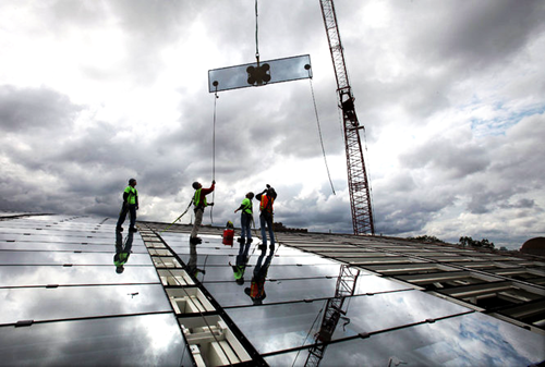
Our vertical construction surveying services include establishing theoretical column lines on completed floors in addition to establishing benchmarks for the use of various subcontractors. Maintaining accurate theoretical column line positions from floor to floor is critical due to the multitude of uses in which this control is utilized. Interior partition walls utilize this control and may contain vertical conduits inside the walls that have very little position tolerance from floor to floor.

Exterior building facades, such as window mullions and glass panels, are placed using our control. Ensuring the window units are installed in the correct position and plumb ensures the exterior façade will not contain shadow lines and is pleasing to the human eye.

We strive to maintain a very tight tolerance in setting vertical construction. This is achieved by erecting many reflective prisms on surrounding buildings. By daily checking of these prisms prior to setting any control, we can adjust as needed for building movement due to warming by the sun.
 

3D Laser Scanning & Tracking

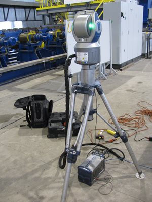
In 2016, R.E. Warner acquired industrial surveying firm Accurate Technologies, creating our Precision Measurements & Mapping group. These specialists use advanced technologies for documentation, measurement and mapping that are not common to most engineering and surveying firms. The high-tech tools provide more data and better accuracy and are also more time- and cost-efficient.

  • 3D Laser Tracking provides large volume field measurements with the highest precision in 3D. The tracker sends a laser beam to a reflective target on an object being measured; the returning beam delivers 3D coordinate data. Software is then used to fit this data to geometrical entities.
  • 3D Laser Scanning generates fast and exact measurements of the real world in 3D with time savings and greater accuracy. The technology also provides non-contact data capture, including color, with accuracy of +/- 2mm. The scanner emits a laser that captures millions of data points in minutes, creating a dense point cloud that is used to create a 3D CAD model.
  • Aerial Photography & 3D Mapping - Unmanned aerial vehicles (drones) can provide high-resolution aerial photography and elevation data collection (3D maps). Aerial photography can be generated with 4 cm pixel images. This dense photography captures small objects that are not visible in most publicly available aerial imagery. The small pixel size also picks up field-located markings as small as 3-4 inches, such as utility locators’ markings, utility reference posts, environmental engineers’ field markings, etc.

Control markers set by field surveyors have a geographic accuracy of ~8 cm within the photography – also exceeding most aerial photography available on the Internet. This data can be geo-referenced for use in GIS systems and CAD drawings, and can be set to state plane or project coordinates. The images can also be brought into AutoCAD and used for accurate background data.

The aerial contour (3D) mapping system captures elevation data accurate to 6 cm with proper ground control, allowing our staff to create elevation contours with an accuracy down to 0.2 feet for mapping, volumetric surveys, and more.

Market Contacts
E-Mail
440-835-9400

Boundary
  • Commercial
  • Residential
  • Lot Splits
  • Consolidation Plats
  • Dedication/Vacation Plats
  • Legal Descriptions
  • ALTA Surveys
  • Easements
Topographic
  • Base Mapping (Microstation & AutoCAD)
  • Plot Plan
  • As-builts
  • Global Positioning Systems (GPS)
Right-of-way
  • Plans
  • Legal Descriptions
  • Surveys
Route
  • Multi-use Paths/Trails
  • Interstate Highways
  • State Routes
  • Rail Lines
Land subdivisions
  • Residential
  • Commercial
  • Industrial Parks
Flood Certification
Construction Layout & Staking
  • Heavy Highway
  • Roadway and Railroad
  • Buildings and Facilities
  • Utilities
  • Sitework
  • Foundations
  • Road/Curb/Drainage Staking
  • Excavation Cut/Fill Staking–Volumes
  • Building Foundation Layout
  • Equipment Foundation Layout
  • Mechanical High Precision Control
  • As-Built Foundation & Bolt Locations
High Precision Horizontal & Vertical Control
  • Project Control and Monumentation
  • Benchmarks
Industrial Construction and Equipment Installation Surveying
  • Vertical Construction Surveying
  • Project Survey Control and Monumentation (standard or high precision to 0.001”)
  • New Installation of Buildings, Equipment & Utilities
  • Existing Equipment Alignment
  • Building layout
  • Equipment foundation layout
  • Equipment layout (high precision optics or 3D laser tracking)
  • As-built verifications (conventional or 3D laser scanning)
  • Benchmarks and alignment records
  • Structural Steel Surveys (conventional or 3D laser scanning)
  • Crane Rail Surveys
  • Utility locations
  • Quality Control
  • Settlement and Movement Reports (comparing 3D laser scan data & modeling)
  • Plant mapping
  • GIS (geographic information systems)
3D Laser Tracking – Metrology (Equipment Alignment & High-Precision Measurements)
  • Project Survey Control
  • Mechanical Equipment Alignment
  • Equipment Alignment Reports
  • Verify Dimensional Accuracy
  • Large Part Measurements
  • In-place inspection of large parts and assemblies
3D Laser Scanning & Modeling
  • Building Information Modeling
  • Emergency Building Mapping
  • Volumetric Surveys
  • As-Built Documentation
Geographic Information Systems & Mapping
  • Aerial Control & Mapping
  • Mobile GIS
  • Facility/Environmental Mapping
  • EPA MS4 Storm Documentation & Mapping
  • Cemetery Mapping
  • Industrial Utility Mapping and Documentation
  • County/Public Mapping
Aerial Mapping
  • Construction progress documentation
  • Pipeline route feasibility studies
  • Verification of utility route encroachments or vegetation growth
  • Real-estate documentation of existing conditions, buildings, improvements, encroachments
  • G.I.S./environmental mapping
  • Studies (land usage, vegetation, wetlands)
  • Security/fire planning and education
Aerial Contour Mapping
  • Engineering designs
  • Drainage studies
  • As-build documentation
  • Cut/fill quantities
  • Pay quantities
  • Material storage quantities
  • Environmental studies
  • Utility routing and mapping
  • G.I.S. data
  • Flood/FEMA studies
  • Land usage study
Commercial
Chemical & Process
Government
Metals
Power & Utility

Related Portfolio

Timken Vertical Caster 3D Laser Tracking

3D laser tracking for construction installation surveying for TimkenSteel's new $200-million vertical steel caster.

Construction Surveying for Flats East Bank Development Phase II in Downtown Cleveland

Ground-up redevelopment of the east bank of the Flats, bounded by downtown Cleveland, the Cuyahoga River and Lake Erie.

Construction Layout and Staking for Opportunity Corridor in Downtown Cleveland

New boulevard improves the transportation system, supports economic development and enhances quality of life for residents.

Learn More

View our portfolio or see our market expertise.

Portfolio
Markets

Join our email newsletter

Back to top
Copyright 2025 R.E. Warner & Associates

Menu

AboutCareers
440-835-9400
440-835-9474
Ohio Office (HQ) 25000 Country Club Blvd., Ste. 340 North Olmsted, OH 44070
440-835-9400
440-835-9474
Alabama Office 1500 1st Avenue N Innovation Depot #99 Birmingham, AL 35203